Product Hunt logo dark
  • Launches
    Coming soon
    Upcoming launches to watch
    Launch archive
    Most-loved launches by the community
    Launch Guide
    Checklists and pro tips for launching
  • Products
  • News
    Newsletter
    The best of Product Hunt, every day
    Stories
    Tech news, interviews, and tips from makers
    Changelog
    New Product Hunt features and releases
  • Forums
    Forums
    Ask questions, find support, and connect
    Streaks
    The most active community members
    Events
    Meet others online and in-person
  • Advertise
Subscribe
Sign in
Subscribe
Sign in
Picterra Tracer

Picterra Tracer

Plot monitoring, reporting, & verification made easy

5.0
β€’1 reviewβ€’

22 followers

Plot monitoring, reporting, & verification made easy

5.0
β€’1 reviewβ€’

22 followers

Visit website
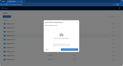
Picterra Tracer is a new, all-in-one product designed to simplify and enhance the process of creating, validating, analyzing, and monitoring land plots and boundaries using geospatial imagery.
  • Overview
  • Launches1
  • Reviews1
  • Team
  • More
Company Info
picterra.ch/picterra-tracer
Picterra Tracer Info
Launched in 2024View 1 launch
Forum
p/picterra-tracer
  • Blog
  • β€’
  • Newsletter
  • β€’
  • Questions
  • β€’
  • Forums
  • β€’
  • Product Categories
  • β€’
  • Apps
  • β€’
  • About
  • β€’
  • FAQ
  • β€’
  • Terms
  • β€’
  • Privacy and Cookies
  • β€’
  • X.com
  • β€’
  • Facebook
  • β€’
  • Instagram
  • β€’
  • LinkedIn
  • β€’
  • YouTube
  • β€’
  • Advertise
Β© 2025 Product Hunt
SocialX
Picterra Tracer gallery image
Payment Required
Launch tags:
Artificial Intelligenceβ€’Climate Techβ€’Farming
Launch Team / Built With
Dan RushtonPierrickFrank de Morsier
Vue.js
Django
Google Earth Engine

What do you think? …

Dan Rushton
Dan Rushton
Maker
πŸ“Œ
🌍 We're very proud to launch Picterra Tracer, a new, all-in-one product designed to simplify and enhance the process of creating, validating, analyzing, and monitoring land plots and boundaries using geospatial imagery. 
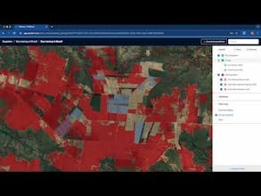
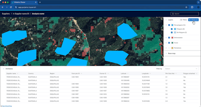
🌱 This versatile product is aimed at producers, operators, and traders involved in the supply chain of soft commodities and forestry, where compliance with environmental regulations and sustainability reporting is critical. Picterra Tracer provides a visually appealing geographic interface to trace commodities to their plots. πŸ—ΊοΈ πŸ’‘ Developed with flexibility and efficiency in mind, Picterra Tracer addresses various use cases. It helps organizations comply with regulations like the European Union Deforestation Regulation (EUDR), validate carbon credit claims, and perform complex environmental monitoring. 🌳 πŸš€ Picterra Tracer works with satellite, drone, or aerial imagery, leveraging open-source layers (through Google Earth Engine) so users can analyze plots accurately and confidently.
Report
9mo ago
GoPerfect - Real-Time Hiring
GoPerfect - Real-Time Hiring β€” Skip the Search. Meet top Candidates fast.
Skip the Search. Meet top Candidates fast.
Promoted

Do you use Picterra Tracer?

5.0
Based on 1 review
Review Picterra Tracer?
Reviews
Helpful
Romain Gratier
Romain Gratier
β€’2 reviews
I am using this for eudr daily tasks and it is the most amazing tool I have found in the market.
Report
7mo ago